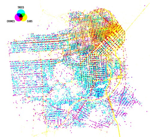
Cartography is all the rage these days due in no small part to the ubiquity of easy to use tools. Beside my own cartographic experiments – most notably Accessible Transit Maps, Australian Territory Expansion and travel maps – there is a large amount of people creating maps from many different data sources. While these examples are not exhaustive, I have tried to collect different examples of this cartographic orgy, breaking them down into different taxonomies.
Maps from Data Sources

Shawn Allen of Stamen Design created this map of San Francisco from data sources of Trees, cabs and crime in San Francisco.
Indirect Crowdsourcing Map Data

Flickr is creating maps by reverse engineering geo-tagged photos (see more here: The Only Question Left Is).
User Created Map Legends

Matt Jones’ photo above is an example of a CloudMade map which creates maps around open mapdata and then allows users to create maps with distinctive legends and data sets.
Historical Analysis – Comparative

The Genealogy of Cities by Professor Charles P. Graves Jr. is a compilation of ancient and modern city plans, from 350 BCE to the present, depicting both built and proposed plans. Comparative in nature, this work aims to provide historians and urban designers a way to compare and contract urban form between physical locations and through time. The Genealogy of Cities also helpfully includes a CD full of digital maps to print out at any scale.
Historical Analysis – Utopias

Work AC: 49 Cities is an analysis of historical urban utopias ranging from Kenzo Tange’s Tokyo Bay project, to Corbusier’s Ville Radieuse. Comparative analysis and analysis of the utopian city itself has been performed for each of the 49 cities. 49 Cities sets out to crunch the numbers of several centuries of unrealized urbanism, all the way from the Roman city to the great utopian projects of the 20th century.
Text Maps – Type Inside Physical Features

<a href="Jenny Beorkrem’s modern, typographic neighborhood posters and screen prints uses existing borders to create artistic representations of physical places.
Text Maps – Removal of Physical Features

London’s Kerning is a typographic map of London. That is, all of the roads and physical features have been removed and in their place only th street names are present.