Category: General
Thursday, Opening Day, Links
- Bryan Nash Gill’s Tree Ring Prints
- The elements of networked urbanism
- Chino Otsuka reshoots an image from a location in childhood and photoshops herself back in ((via)
- Video animates the “Idaho stop”
- The Shining carpet print is in Toy Story
- Brooklyn Community Board Cuts Off Developers’ Fingers
- A Message To You, Teabaggers
- Sweet Juniper’s photos of an abandoned Detroit block
Wednesday, Tax Day, Links
- Conservatives Analogizing Themselves to Violent Terrorists
- Using the Hudson to Cool the Trade Center
- Thomas Doyle’s marvelous diorama art
- BLDGBLOG Book & Behind the Scenes of The BLDGBLOG Book
- Know Your Meme – brilliant videos
- Like FFFOund for type: We Love Typography
- Consumers and Health Care
- The Graffiti Debate: Glorifying art or vandalism?
- Smithsonian picks architects, design for African-American museum
Tuesday, Pirates Aren’t Funny, Links
- Pritzker Prize Goes to Peter Zumthor
- Biking Has Its (Tax) Benefits. Or Does It?
- Few Good Options in Pirate Fight
- London as Language
- Enclosing the BQE
- Knucklehead Politicians Want to Tear Down Beautiful Train Station
- Conservative Anti-European Rhetoric Reflects Distinctive Southern Attitudes
- Shoring Up a Landmark Ruin on Roosevelt Island
Typologies from the New Cartographic Explosion
Cartography is all the rage these days due in no small part to the ubiquity of easy to use tools. Beside my own cartographic experiments – most notably Accessible Transit Maps, Australian Territory Expansion and travel maps – there is a large amount of people creating maps from many different data sources. While these examples are not exhaustive, I have tried to collect different examples of this cartographic orgy, breaking them down into different taxonomies.
Maps from Data Sources
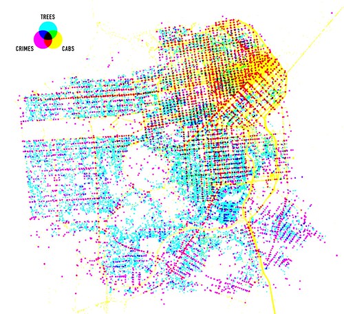
Shawn Allen of Stamen Design created this map of San Francisco from data sources of Trees, cabs and crime in San Francisco.
Indirect Crowdsourcing Map Data

Flickr is creating maps by reverse engineering geo-tagged photos (see more here: The Only Question Left Is).
User Created Map Legends

Matt Jones’ photo above is an example of a CloudMade map which creates maps around open mapdata and then allows users to create maps with distinctive legends and data sets.
Historical Analysis – Comparative

The Genealogy of Cities by Professor Charles P. Graves Jr. is a compilation of ancient and modern city plans, from 350 BCE to the present, depicting both built and proposed plans. Comparative in nature, this work aims to provide historians and urban designers a way to compare and contract urban form between physical locations and through time. The Genealogy of Cities also helpfully includes a CD full of digital maps to print out at any scale.
Historical Analysis – Utopias

Work AC: 49 Cities is an analysis of historical urban utopias ranging from Kenzo Tange’s Tokyo Bay project, to Corbusier’s Ville Radieuse. Comparative analysis and analysis of the utopian city itself has been performed for each of the 49 cities. 49 Cities sets out to crunch the numbers of several centuries of unrealized urbanism, all the way from the Roman city to the great utopian projects of the 20th century.
Text Maps – Type Inside Physical Features

<a href="Jenny Beorkrem’s modern, typographic neighborhood posters and screen prints uses existing borders to create artistic representations of physical places.
Text Maps – Removal of Physical Features

London’s Kerning is a typographic map of London. That is, all of the roads and physical features have been removed and in their place only th street names are present.
Monday, Zombie Jesus, Links
The Insanity of a World Without Carbon Pricing

If you aren’t listening to the Planet Money Podcast you should. Because if you did, you would have listened to last weeks episode, That Lime Green Coat, which discussed how people in the UK not buying expensive designer coats is affecting Cairo bread makers (via the Suez Canal). They interviewed a representative from Maersk Line Shipping discussing that due to the economy, they were not shipping through the Suez Canal, opting to go around the Horn of Africa because the fuel and time cost were less than the canal tolls. And apparently, the cost of piracy as today a US Flag Maersk carrier was hijacked.
This decision to forgo speed for cost savings is a rational decision, insofar as carbon and fuel is priced unduly low. In a world where the externalities of burning an additional 12 days worth of fuel to save canal tolls would be correctly priced, the carrier would chose the canal every time. Only because we have all bought into the fiction that carbon shouldn’t be priced is this allowed. Carbon Pricing would fix this insanity.
I mean, just look at the above map. Madness.
Stadium designer HOK Sport has rebranded itself as Populous

HOK Sport rebrands as Populous:
The firm, which employs around 500 staff around the world, underwent a management buy-out from parent company HOK Group last December, led by senior principal Rod Sheard among others.
Sheard said: “What we do best is design buildings that draw people together so Populous is the perfect name to reflect our business.
“Whether it’s for sports and entertainment or exhibits and conferences, our aim is to create buildings that people love to be in, and which can become a point of reference and rejuvenation for their communities.
I doubt that the new firm will be flattening the land so his people can go from tents, to log cabins, to castle keeps to full castles, but just in case, can someone warn me when the Blue Tribe will attack the Red Tribe before Armageddon occurs?
And why announce this name change on April Fools Day?
A Video to Counteract Internet Jackass Day
Tuesday, Auto Bailouts Should Begin with Giving Me a Free Car, Links
- 1001 Rules For My Unborn Son
- All 120 Crayon Names, Color Codes and Fun Facts
- The Problem of the Senate
- Arial Redux
- The Obama Auto Plan
- On Hoaxes (or not), Twitter, And The Pleasures of Digging (and not the Kevin Rose kind.)
- America’s bankers are oligarchs
- When Are We Going To Start Talking About The Environmental Cost Of Solar?
- The World’s 7 Best High Speed Rail Networks
- Three notebooks by Lebbeus Woods
- It’s a Kindle World Now
- Tizzy Over Downplayed “Freedom” At 1 World Trade Center