TimeMaps: Showcasing Duration, not Distance

TimeMaps by Dutch designer Vincent Meertens redraws transit maps according to how long the trip is from any two points in the Netherlands:

Due to the good public transportation in the Netherlands distance has become irrelevant. We can reach almost any destination by train easily and relatively quick. In our busy lives we now think in time rather than distance. Therefore the current maps, as we know them today, are obsolete. Thinking in time affects a map and hence the shape of the Netherlands also depending on the perspective from which we look. From the perspective of Eindhoven, for instance, the Netherlands is relatively small because of the quick and easy connections to other cities. At the same time, seen from a more remote and small village such as Stavoren the Netherlands is much bigger. Not only the location from which one looks, or travels, but the hour of the day is very important. At night the map will expand because there are no night trains and in the morning it will shrink once trains will commence their schedules. The map of the Netherlands will never be the same again.

See also:

NYC grid everywhere: Mumbai, India

What does the New York City grid look like if we extend it throughout the world? Well, Extend NY helps visualize what those streets look like.

Right now I’m at the intersection of East 74,461 Ave and 94,097th Street. Which subway should I take home?

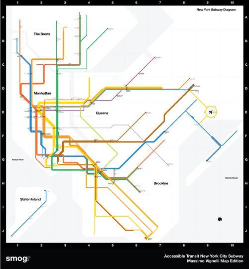
Accessible Transit Massimo Vignelli NYC Subway Map Edition

AM_Vignelli_NYCTA_01

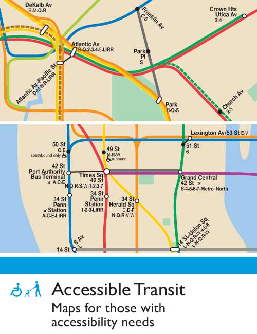
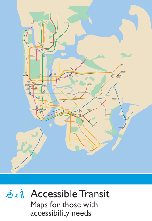
This is the third installment of my Accessible Transit Map series. Intended as a replacement map for those with disabilities, this map illustrates which station stops on the New York City Transit Authority’s system is accessible for those with strollers or with a disability.

This map is special: it is the updated system map by Massimo Vignelli, a design which is beautiful but which I have been a vocal critic of. For those who don’t know about Vignell’s 1972 map, read Michael Bierut’s history, Mr. Vignelli’s Map which is very well written.

As in previous maps, I have removed all stations which are not handicapped accessible. Maps represent corporeal objects, through convenient fictions; a representation which works for a majority of its users. But where are the maps for the disabled or those require additional accessibility? Wouldn’t the mother with newborn in stroller need a different map then those without the need to lug all the accoutrement’s of childhood? Equally, those in a wheelchair require a map different then one which the walking can use. I decided to rectify the situation by editing the maps of major metropolitan transportation systems, in order to create a map for those who are not represented on the official map.

Here are details of the map:

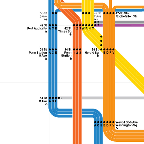
Midtown Detail

AM_Vignelli_NYCTA_02

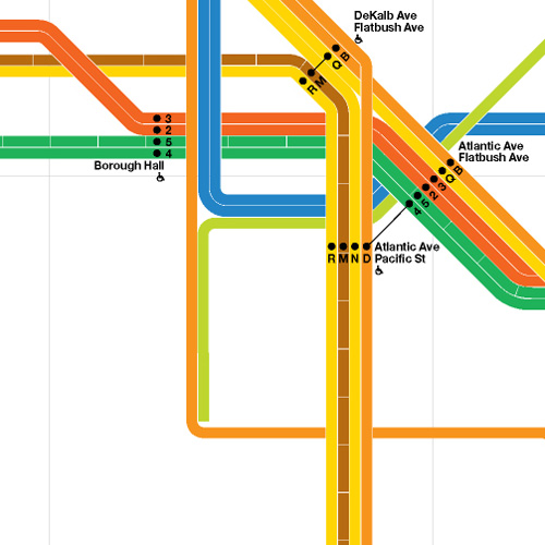
Brooklyn Detail

AM_Vignelli_NYCTA_03

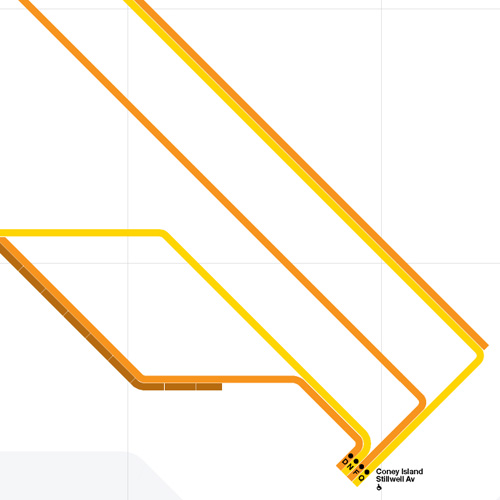
Coney Island Detail

AM_Vignelli_NYCTA_04

From the three details shown above the system map gradually becomes more beautiful as you strip information away; as more and more stations are removed, the system becomes more diagrammatic and pure. This is the issue I have with Vignelli’s original, and update map: the subway is not an abstract diagram, no matter that the designer wishes it to be. No matter that Vignelli has created a masterpiece of design, the system will never be forced into the visual language that London’s Underground uses so successfully. As so it will be: the historical traces of over one hundred years of service, created by three different companies, will continue to bleed through time into today’s maps.

Feel free to download the map in pdf format: Accessible Transit Massimo Vignelli NYC Subway Map Edition.

Other Accessible Transit Maps for your perusal:

Please see also:

Radical Cartography – Boston College Town

Radical Cartography - Boston College Town

Boston is certainly a college town, but most maps show only the smallest version of the university campus – the quad, major buildings, maybe some dorms. Using municipal property databases, I made a campus map that shows land owned by the thirty-two colleges and universities in the inner Boston area, including land that is leased for non-university uses. Where possible, I also included land that is owned by school-controlled holding companies.

Radical Cartography – Boston College Town.

Accessible Transit – New York City Subway – Update

NYC-subwaymap-detail

My Accessible Transit – New York City Subway article has been found again and there are some general questions about the methodology. This map was created based on data I collected from the MTA’s website based on accessible stations as of Quarter 3 of 2007. As update occur based on the elevators coming in an out of service, I’ll update the map.
But the basic fact of the matter is that for those with accessibility issues, the NYC Subway is a huge barrier.
As per requests, here is a Accessible Transit – New York City Subway PDF version (1.1 mb pdf).

Accessible Transit – New York City Subway

For most of us just getting around the major subway systems of the world is difficult enough. What would a transit system look like if you were disabled or in a wheelchair?

NYC-subwaymap-detail

This is my second installment of my Accessible Transit Map series. Intended as a replacement map for those with disabilities, this map illustrates which station stops on the New York City Transit Authority’s system is accessible for those with strollers or with a disability. This is a companion map to my Accessible Transit – London Underground issued last year.

NYC-subway-small

You can see that there is a great number of the 422 stations along the 656 miles of revenue track. Here is a List of New York City Subway Stations, where you can sort by accessibility.
Update – 20 April 2008
This article has been found again and there are some general questions about the methodology. This map was created based on data I collected from the MTA’s website based on accessible stations as of Quarter 3 of 2007. As update occur based on the elevators coming in an out of service, I’ll update the map.
But the basic fact of the matter is that for those with accessibility issues, the NYC Subway is a huge barrier.
As per requests, here is a Accessible Transit – New York City Subway PDF version (1.1 mb pdf).
For other mapping product, please see:

Accessible Transit – London Underground

For most of us just getting around the major subway systems of the world is difficult enough. What would a transit system look like if you were disabled or in a wheelchair? I became very curious in this and started to collect maps of different transit systems around the world.
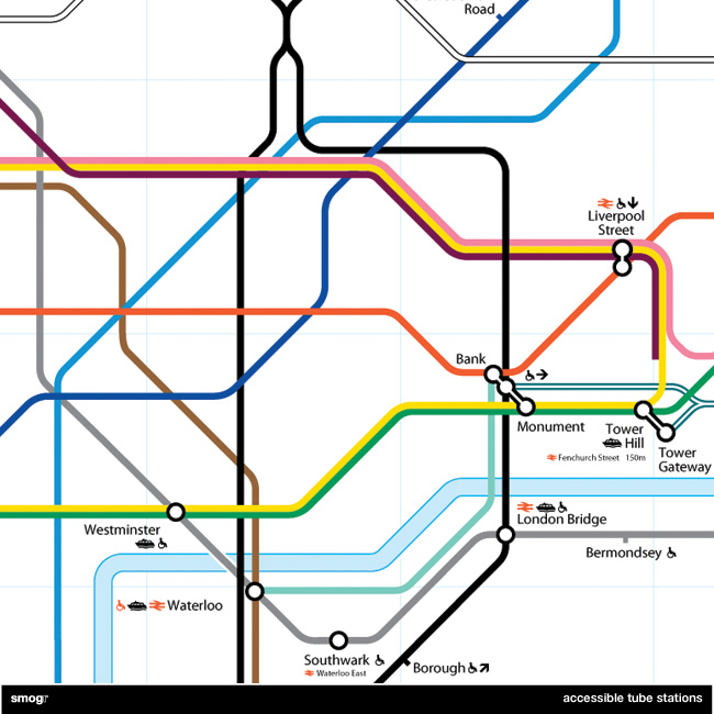
London-Underground-detail

Accessible Transit – London Underground Detail

And then it occurred to me: if maps virtually represent life, through convenient fictions, then why are there no maps for those who are disabled or require additional accessibility? Wouldn’t the mother with newborn in stroller need a different map then those without the need to lug all the accoutrement’s of childhood? Equally, those in a wheelchair require a map different then one which the walking can use. I decided to rectify the situation by editing the maps of major metropolitan transportation systems, in order to create a map for those who are not represented on the official map.

My first Accessible Transit Map was the London Underground map, which can be downloaded in the following versions:

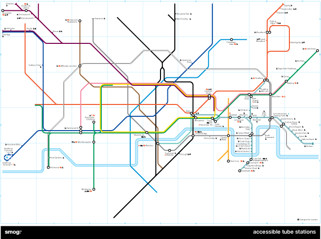
As you can see from the detail below, those of you needing better accessibility have limited options; the DLR and the Jubilee Line are your best choices.
London-Underground-small

I realize that Transport for London has been making great strides in retrofitting many stations in order to comply with DDA requirements. TfL is doing what they can with hundreds of years old infrastructure and have an extensive transport accessibility system including Dial-a-Ride, which will pick up a disabled person and transport them. They are installing tactile warning surfaces on stairs and at the platform edge, and I’ve noticed the staff is generally helpful to those with disabilities.

But all of this doesn’t change the fact that maps have an intrinsic reality; a reality which those of us with proper ambulatory functions take for granted. Of course Transport for London won’t issue this map as an official Underground map because the map looks really, really bad (not to mention this would be really confusing for the Yank tourists). Not even half of the system’s tube stations – I count 82 out of 275 stations – are accessible.

Lest my reader believes I am picking on the fair city of London, be still. The New York City Subway maps is coming soon; it took longer because the graphics file is horrendously large and difficult to work with.