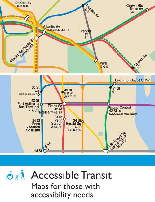
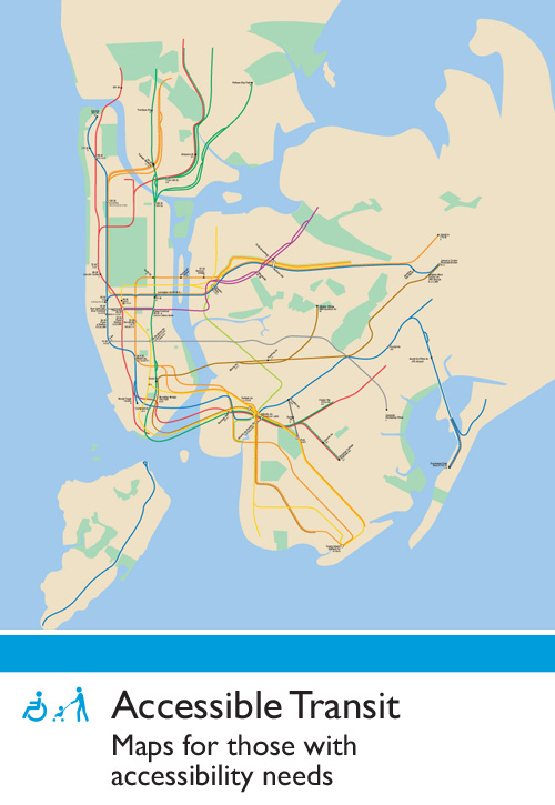
My Accessible Transit – New York City Subway article has been found again and there are some general questions about the methodology. This map was created based on data I collected from the MTA’s website based on accessible stations as of Quarter 3 of 2007. As update occur based on the elevators coming in an out of service, I’ll update the map.
But the basic fact of the matter is that for those with accessibility issues, the NYC Subway is a huge barrier.
As per requests, here is a Accessible Transit – New York City Subway PDF version (1.1 mb pdf).
Tag: NYC
Accessible Transit – New York City Subway
For most of us just getting around the major subway systems of the world is difficult enough. What would a transit system look like if you were disabled or in a wheelchair?
This is my second installment of my Accessible Transit Map series. Intended as a replacement map for those with disabilities, this map illustrates which station stops on the New York City Transit Authority’s system is accessible for those with strollers or with a disability. This is a companion map to my Accessible Transit – London Underground issued last year.
You can see that there is a great number of the 422 stations along the 656 miles of revenue track. Here is a List of New York City Subway Stations, where you can sort by accessibility.
Update – 20 April 2008
This article has been found again and there are some general questions about the methodology. This map was created based on data I collected from the MTA’s website based on accessible stations as of Quarter 3 of 2007. As update occur based on the elevators coming in an out of service, I’ll update the map.
But the basic fact of the matter is that for those with accessibility issues, the NYC Subway is a huge barrier.
As per requests, here is a Accessible Transit – New York City Subway PDF version (1.1 mb pdf).
For other mapping product, please see:
The 51st State – State of New York City
The perennial question of New York City succeeding from New York state or the Union reared it’s head again (the legal term is really separation). The most persuasive recent argument was expressed in depth in NY Magazine, The Independent Republic of New York:
As New York—a city that often has more in common with Europe than with the United States—prepares to be invaded by the red-state hordes during an election that has much of the city fearing the prospect of four more years, a persistent fantasy resurfaces—should New York secede?
As one of Gothamist’s commenter’s stated, Given enough time, Jimmy Breslin and Norman Mailer will be proven true.
So I decided to look at what this fictional Sate of New York City would look like. Would it be like Athens or Sparta of old, amorphous city states? Probably not. Setting aside the notion that the States of New York, New Jersey and Connecticut would give up any of their sovereign land (or if it could be done), the most basic building block of America is the County (the township being superseded). Below is what I came up with:

Naturally the Five Boroughs would form the nucleolus of the new state. Long Island is a natural extension of the 51st state, with excellent road and rail connections and historical connections with the City itself. Westchester also should/would be annexed as a majority of citizens commute on a daily basis and I’m sure the tax rate could induce separation. With the creation of the Port Authority of NY & NJ over eighty years ago, the eastern sections of New Jersey are tightly intertwined with NYC proper. Similarly Fairfield County in Connecticut is a large bedroom community for the City.
While the State of New York City would never happen, it gives politicians something to threaten with and newspapers column inches to print, and urbanities something to talk about.
For those interested in just how a part of a state could separate and form a new state in the Union, you should look at the history of West Virginia’s Separation from Virginia. Preceded by years of geographical and cultural isolation and the Virginia legislature’s vote to secede from the Union, the process of West Virginia’s separation from Virginia was:
- Mass meeting at Clarksburg
- The First Wheeling Convention
- The Second Wheeling Convention which ruled that the Virginia government illegally succeeded from the Union and by succeeding vacated their offices
- Legislature of the Reorganized Government of Virginia – Virginia effectively had two governments
- A
statewide
popular referendum of those counties which wished to separate - Constitutional Convention
- Confederate Virginia approves separation
- Congressional Debate and acceptance
- Signature of the President
- Supreme Court case Virginia v. West Virginia – West Virginia won
All in all, West Virginia’s separation from Virginia took 78 years , a payment of $12.4 million and a war (it took 9 years for separation and the remaining balance to settle lawsuits and settling of debt).
I would presume that for the New York City region to separate from three states and form a new state would take a crisis of similar scope and severity. Global warming related rising of the sea level threatening NYC with the State not moving to protect the city could be a crisis situation which would precipitate a successful separation.
What about your thoughts?
New York Penn Station Terminal Service Plant

The Penn Station Service Building; A 1908 Structure Survives A ‘Monumental Act of Vandalism’:
The service plant held the key to the railroad’s new operation, for it provided the electric power for the engines in and out of New York. Research by the industrial archaeologist Thomas Flagg indicates that it was also used to supply heat, light, elevator hydraulics and refrigeration for the station as well as compressed air for braking and signaling. It even incinerated the station’s garbage.
The mid-block building, 160 feet long and 86 feet high, is divided by a north-south fire wall with boilers for power generation on the west side and power distribution, offices and other elements on the east.
The station and the service plant were designed by McKim, Mead & White, specifically Charles McKim and partner William Symmes Richardson. Writing in Transactions of the American Society of Civil Engineers for October 1910, Richardson said that, on the station itself, “all unnecessary detail of ornamentation was omitted.”
For the service building the architects assembled some of the simplest elements from the station in the Stony Creek pink granite.
The Roman Doric exterior, a row of severe pilasters bracketing ventilation windows covered with iron grills, is about as plain as a building can get and still have an identifiable style. Cleaned, it could be a post-modern historical society or a crematorium.


All photos care of the Library of Congress:
New York Penn Station Terminal Service Plant
New Museum Scales
 IMG_5641.JPG, originally uploaded by emily geoff


