Accessible Transit Massimo Vignelli NYC Subway Map Edition

AM_Vignelli_NYCTA_01

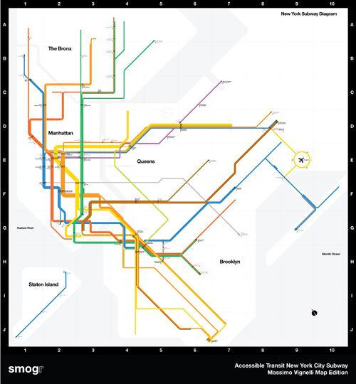
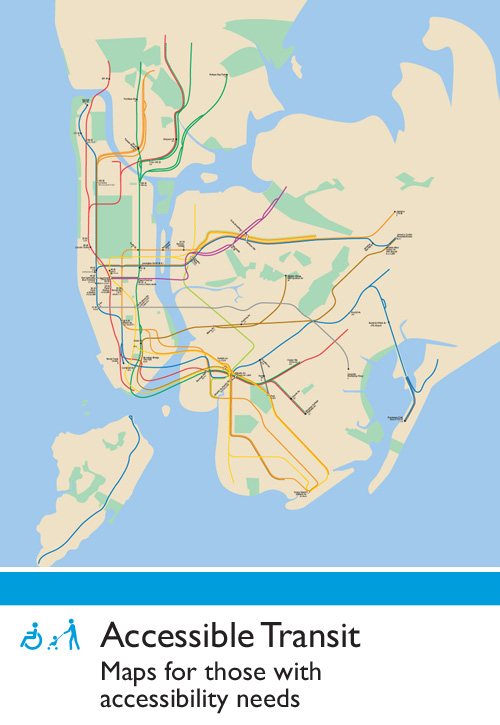
This is the third installment of my Accessible Transit Map series. Intended as a replacement map for those with disabilities, this map illustrates which station stops on the New York City Transit Authority’s system is accessible for those with strollers or with a disability.

This map is special: it is the updated system map by Massimo Vignelli, a design which is beautiful but which I have been a vocal critic of. For those who don’t know about Vignell’s 1972 map, read Michael Bierut’s history, Mr. Vignelli’s Map which is very well written.

As in previous maps, I have removed all stations which are not handicapped accessible. Maps represent corporeal objects, through convenient fictions; a representation which works for a majority of its users. But where are the maps for the disabled or those require additional accessibility? Wouldn’t the mother with newborn in stroller need a different map then those without the need to lug all the accoutrement’s of childhood? Equally, those in a wheelchair require a map different then one which the walking can use. I decided to rectify the situation by editing the maps of major metropolitan transportation systems, in order to create a map for those who are not represented on the official map.

Here are details of the map:

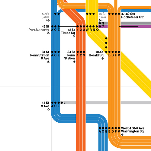
Midtown Detail

AM_Vignelli_NYCTA_02

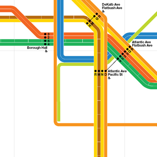
Brooklyn Detail

AM_Vignelli_NYCTA_03

Coney Island Detail

AM_Vignelli_NYCTA_04

From the three details shown above the system map gradually becomes more beautiful as you strip information away; as more and more stations are removed, the system becomes more diagrammatic and pure. This is the issue I have with Vignelli’s original, and update map: the subway is not an abstract diagram, no matter that the designer wishes it to be. No matter that Vignelli has created a masterpiece of design, the system will never be forced into the visual language that London’s Underground uses so successfully. As so it will be: the historical traces of over one hundred years of service, created by three different companies, will continue to bleed through time into today’s maps.

Feel free to download the map in pdf format: Accessible Transit Massimo Vignelli NYC Subway Map Edition.

Other Accessible Transit Maps for your perusal:

Please see also:

Bad Day For the SUPERTRAIN

Yesterday was a bad day for the SUPERTRAIN around the world. In Los Angeles a Metrolink commuter train collided with a Union Pacific freight train: At Least 18 Killed as Trains Collide in Los Angeles. the same day a Freight Train Fire in Channel Tunnel shut down the Franco-English tunnel; there were no casualties, but it is unclear what structural damage occurred inside the tunnel.

Both accidents illustrate how our current rail infrastructure is running at capacity. Freight and passenger service must be segregated on their own right-of-ways and capacity, especially in high-traffic areas such as Los Angeles, must be increased.

Update 9/14

Apparently the Metrolink engineer missed a red signal which caused the passenger train to collide with the freight train. Sad.

SUPERTRAIN to the Game

I attend Friday’s U.S. Open tennis match in Flushing Meadows (Queens), which increased my East Coast Liberal Elitism a step forward (gift baskets arriving soon!) by not only watching Tennis but also taking the SUPERTRAIN to the game. The USTA Billie Jean King National Tennis Center in Flushing Meadows is a very nice facility, but it is nowhere close to where I live or work. Luckily it is served by both the 7 Train and the Long Island Railroad. The LIRR isn’t quite the SUPERTRAIN but the trip was only 12 minutes, considerably shorter then the estimated 90 minutes by subway. That is SUPER enough for me.

Penn Station

This trip underscored how many parts of the SUPERTRAIN experience need to be operating in top form in order to provide a smooth, stress-free trip. Not only do you need efficient transportation at both departing and arriving stops, but you need logical path of travel in both departing and arriving stations so that you can make your 7:04 train. This includes clear signage throughout your journey, especially at stations, not to mention clear announcements of station stops.

Madison Square Garden Ceiling
LIRR fails (Epic Transit Fail) spectacularly when it comes to Penn Station, or what remains of Penn Station. A multi-modal station which was destroyed in order to build an sub-urban basketball arena, what’s left is a rabbit-worn maze of 9′-0″ high corridors. Exasperating the situation is that there are, at minimum, three waiting areas: one each for LIRR, Amtrak and NJ Transit. There is no central waiting room such as at Grand Central (not to mention a lack of any celebration of entry or exit which arriving and departing at Grand Central) and the station spans two floors (not counting the track level).

Penn Station is perhaps the only major urban station which treats its passenger’s in such a manner. We can only hope that the future Moynihan Station will wiggle free from the current logjam and Penn Station will again be a dignified entry to New York City.

Accessible Transit – New York City Subway – Update

NYC-subwaymap-detail

My Accessible Transit – New York City Subway article has been found again and there are some general questions about the methodology. This map was created based on data I collected from the MTA’s website based on accessible stations as of Quarter 3 of 2007. As update occur based on the elevators coming in an out of service, I’ll update the map.
But the basic fact of the matter is that for those with accessibility issues, the NYC Subway is a huge barrier.
As per requests, here is a Accessible Transit – New York City Subway PDF version (1.1 mb pdf).

Access to the Region’s Core in NY Times

the tunnel project study map
I’ve written about Access to the Region’s Core – the new two-track rail tunnel under the Hudson River, but today The New York Times has an extensive write-up of the project, Tunnel Milestone, and More to Come:

But the tunnels reached their peak-hour capacity in 2003 when the Secaucus transfer hub opened. So New Jersey Transit and the Port Authority of New York and New Jersey are planning to spend $7.6 billion to build a second set that will more than double, to 48 an hour, the number of trains that can traverse the Hudson.
The project, called Access to the Region’s Core, or ARC, is in some ways as monumental as the first tunnels, which cost the Pennsylvania Railroad $111 million, a price tag that included the old Pennsylvania Station and four other tunnels under the East River. (It’s about $2.5 billion now when accounting for inflation.)
If federal approval is given this summer and grants are secured later this year, construction will begin in early 2009 and take eight years. Contractors will deploy boring machines the length of football fields to drill through granite, schist and other materials, use laser-guided satellite signals to pinpoint their location, and carve a path under 34th Street so wide that commuters will be able to walk underground to 14 subway lines, and to PATH, Amtrak, New Jersey Transit and Long Island Rail Road trains.

Also see a multimedia explanation about the two different tunnels and what the Future Stewart Express Might Look Like which would utilize the new tunnels.

What the Future Stewart Express Might Look Like

Virgin Wing
I’ve discussed the Port Authority’s new Hudson tunnel project for Stewart International Airport before but there is a new, if fluffy, article in the WSJ, Sending Fliers Up the River To Ease Traffic:

Stewart Airport, an abandoned Air Force base 60 miles up the Hudson River from Manhattan, is being transformed into a fourth airport for the Port Authority of New York and New Jersey, New York’s airport operator.

Chicago proposed creating a third airport in Peotone, Ill., but airlines fought the proposal vehemently. Los Angeles has pumped lots of money into Palmdale, Calif., hoping to make it a reliever for the congested LA Basin, but so far only United Airlines is offering limited, subsidized service.
The idea has worked elsewhere. London’s satellite airports in the countryside have been growing rapidly, driven largely by discounters easyJet and Ryanair. Boston is ringed by several competing airports with commercial service, from big operations at Providence, R.I., and Manchester, N.H., which have become major destinations for Southwest Airlines and others, to fledgling development at Worcester, Mass., and former military bases in Portsmouth, N.H., and Bedford, Mass. Skybus now flies to Portsmouth, formerly Pease Air Force Base about 44 miles from Boston.

What is missing in this cheerleading is investigating why exactly the the airports noted above work. The difference between successful reliever airports, moderately successful reliever airports and unsuccessful reliever airports has everything to do with transportation. London’s Gatwick, Stansted and Luton airports are all successful because they have direct rail links to Central London which takes 30 minutes (Gatwick) to 45 minutes (Luton & Stansted). Additionally, for anyone who has repeatedly flown in and out of London’s Heathrow airport, the chance at flying to a different airport and take a similarly long train to centre London is greatly appealing.1 The Boston airports, Providence, Manchester & Portsmouth all have direct bus connections with Boston’s South Station with an under-hour trip.
For Stewart to become a fully-functioning reliever airport, two things must happen: the three New York airports, La Guardia JFK & Newark must continue their slide into chaos and delay, thus making the trip to Stewart palatable; or, a dedicated single-seat (and quick – a trip of no more then 45 minutes) train service from Stewart-to-Penn Station must be built. Both have costs: time and lost revenue for the airlines, and the cost of connecting Stewart with Penn Station.

Gatwick Express photo by Les Chatfield

Here is how it could be done:
It currently takes 1 hour 33 minutes from Salisbury Mills/Cornwall, the closest Metro-North station, to NY Penn Station with a change at Secaucus Junction.2 The future Stewart Express, would not only need to connect from Salisbury Mills/Cornwall. Suffice to say, this travel time would be trimmed by the Access to the Region’s Core tunnel project, but one problem which will hamper this line is the existing two track right of way. This will need to be upgraded to a minimum three track, but realistically, four track ROW in order to safely operate the Stewart Express to and from Penn Station. An additional staging/repair yard would need to be located somewhere in the system for the additional Stewart Express trains. This is all predicated on being able to purchase, or use the State’s power of eminent domain, to acquire the additional ROW to access Stewart and appropriating the capital expenditure required to build and upgrade the line.
Stewart Express map

ROW of the mythical Stewart Express

All of this adds up to a very long-term project, which in today’s political climate doesn’t have a great deal of chance without a strong support throughout all levels of government.

  1. I deeply love waiting in the cattle pen-like security line, or the three different security checks LHR presents current travellers &#8617
  2. Current riders travel 69 minutes on a local train from Salisbury Mills/Cornwall to Secaucus Junction, wait approximately 10 minutes and then take a NJ Transit train an additional 15 minute NY Penn Station. See complete timetable (pdf) &#8617

Accessible Transit – New York City Subway

For most of us just getting around the major subway systems of the world is difficult enough. What would a transit system look like if you were disabled or in a wheelchair?

NYC-subwaymap-detail

This is my second installment of my Accessible Transit Map series. Intended as a replacement map for those with disabilities, this map illustrates which station stops on the New York City Transit Authority’s system is accessible for those with strollers or with a disability. This is a companion map to my Accessible Transit – London Underground issued last year.

NYC-subway-small

You can see that there is a great number of the 422 stations along the 656 miles of revenue track. Here is a List of New York City Subway Stations, where you can sort by accessibility.
Update – 20 April 2008
This article has been found again and there are some general questions about the methodology. This map was created based on data I collected from the MTA’s website based on accessible stations as of Quarter 3 of 2007. As update occur based on the elevators coming in an out of service, I’ll update the map.
But the basic fact of the matter is that for those with accessibility issues, the NYC Subway is a huge barrier.
As per requests, here is a Accessible Transit – New York City Subway PDF version (1.1 mb pdf).
For other mapping product, please see:

Port Authority to give $3B to new Hudson tunnel project

, originally uploaded by michael cinque

Another $1B slated for tunnel for the new Hudson rail tunnel named Access to the Region’s Core:

The Port Authority of New York and New Jersey will provide another $1 billion to build a tunnel to carry trains under the Hudson River, bringing its total contribution to the $7.5 billion project to $3 billion.
The authority had committed $2 billion to the tunnel, which is scheduled to be completed by 2017. The agency operates the region’s airports, the bridges and tunnels that carry automobiles between New Jersey and New York City, and the PATH train system.
New Jersey Transit says the tunnel will almost double the number of trains that can travel into Manhattan at rush hour, easing congestion as more commuters switch to mass transit amid rising gas prices and more crowded highways, and reducing travel time into the biggest city in the United States.

The authority also will ask the board today to approve a toll increase of $2 on its Hudson River and Staten Island crossings and a 50-cent raise on PATH train fares, the Star-Ledger of Newark reported Wednesday, citing unidentified transportation officials.

the tunnel project study map
The project aims at connecting the Main/Bergen/Pascack Valley Lines of New Jersey Transit with the North East Corridor service. Passengers will be able to take a “one seat journey” to NY Penn Station instead of transferring at Secaucus. A new 6 track terminal facility will be constructed under 34th Street with connections to the existing Penn Station. Additionally, the two new single-track tunnels will be linked to the existing Penn Station facility to facilitate periodic repairs and maintenance on the existing 1917 Hudson Tunnels.
the_tunnel NY Penn Station Cross Section
Taking the long view, the linking of the NJ Transit Main/Bergen/Pascack Valley Lines to Penn Station will allow rail service to the Port Authority’s newest airport acquisition, Stewart International Airport, some 55 miles north of NYC via the Port Jervis Line. This rail link will be necessary to make this facility commercially viable, much like the rail links to London’s Gatwick, Stansted and Heathrow airports.